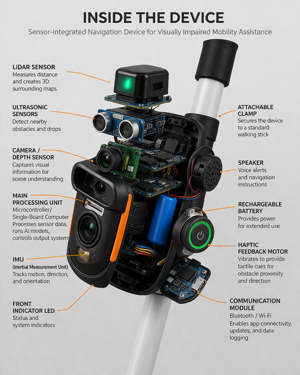
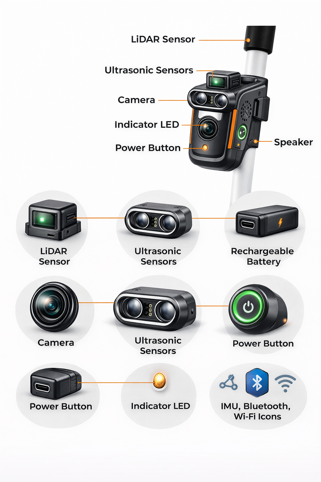
Sensor-Integrated Attachable Navigation Device for Visually Impaired Mobility Assistance

Empowering independence through intelligent assistive technology

AI-Powered Multi-Sensor Real-Time Navigation Accessibility First
Visually impaired person with cane
Smart glasses
Smart cane
System architecture diagram

Presented by

Ojasvi Mishra, Akhil Mor, Nitin Mishra, David Lakra

Lovely Professional University, Punjab-144411, India

02 / Inventors

Meet the Team

OM

Ojasvi Mishra

UID: 12324518

ojasvimishra9792@gmail.com

+91 9044256927

AM

Akhil Mor

UID: 12307177

busysan125@gmail.com

+91 83076 03629

NM

Nitin Mishra

UID: 12306101

nitinmishra979318@email.com

+91 95802 40030

DL

David Lakra

UID: 12323849

lakradavid396@gmail.com

+91 7205187469

Lovely Professional University, Punjab-144411, India

03 / Problem Statement

The Challenge We Address

Global Statistics

Over 285 million people worldwide are visually impaired, with 39 million completely blind. Navigation remains one of their biggest daily challenges.

Traditional White Cane Limitations

Only detects obstacles at ground level within 1-2 meters. Cannot identify overhead hazards, moving objects, or provide directional guidance.

Safety Concerns

High risk of collisions with obstacles outside cane range. Difficulty navigating unfamiliar environments independently.

Visually impaired person navigating with white cane

Limited detection range of traditional white cane

Blind spots: Overhead, beyond 2m, fast-moving objects

04 / Current Solutions

Existing Solutions & Limitations

Screen reader software

Screen Readers

JAWS, NVDA, VoiceOver provide digital accessibility but no physical navigation support.

No obstacle detection
Digital-only assistance
Smart glasses wearable tech

Smart Glasses

OrCam, Envision AI offer camera-based assistance with voice feedback.

High cost ($2,000-5,000)
Battery limitations
Smart cane for blind

Smart Canes

WeWALK, SmartCane add ultrasonic sensors to traditional canes.

Limited detection range
No AI-based object recognition

Key Gap: No existing solution combines multi-sensor fusion, AI-powered object detection, GPS navigation, and affordable pricing in a portable, attachable form factor.

05 / Proposed Solution

Our Innovation

Smart Attachable Navigation Device

A compact, sensor-rich device that attaches to any standard white cane or can be worn independently, providing comprehensive environmental awareness through AI-powered analysis.

360°
Detection Coverage
<100ms
Response Time
5m
Detection Range
<$300
Target Price
Universal Attachment Modular Design Weather Resistant
Electronic sensor components LiDAR ULTRASONIC

Compact design with multi-sensor array

06 / System Architecture

Hardware & Software Integration

Electronic hardware components

Hardware Components

Ultrasonic Sensors (HC-SR04)
Close-range obstacle detection (2cm - 4m)
LiDAR Module (RPLidar A1)
360° scanning, 12m range mapping
Camera Module (OV2640)
2MP resolution for object recognition
GPS Module (NEO-6M)
Location tracking & navigation
IMU (MPU6050)
Motion tracking & orientation sensing

Software Stack

AI/ML Engine YOLO, CNN, TensorFlow Lite
Sensor Fusion Layer Kalman Filter, SLAM
Navigation Core A* Pathfinding, GIS
Feedback Controller Audio, Haptic, Voice
07 / Working Principle

How It Works

Data processing and AI analysis
1. Sense
Multi-sensor data capture
2. Process
AI analysis & fusion
3. Decide
Navigation commands
4. Alert
Audio & haptic feedback

Obstacle Detection

  • LiDAR scans 360° environment
  • Ultrasonic covers blind spots
  • Camera identifies object types
  • Distance calculated in real-time

Data Processing

  • Sensor fusion combines inputs
  • YOLO detects people, vehicles
  • SLAM builds local map
  • AI predicts collision risk

Feedback Output

  • Voice announces obstacles
  • Haptic vibration intensity varies
  • Turn-by-turn navigation
  • Emergency alerts for hazards
08 / System Diagram

Architecture Overview

System Architecture

System Architecture Diagram

Inside Dissection

Inside Dissection

Probable Look of the Product

Probable Look of the Product
09 / Key Features

What Sets Us Apart

AI and robotics technology

Multi-Sensor Integration

Combines LiDAR, ultrasonic, camera, GPS, and IMU for comprehensive environmental perception. No single point of failure.

Real-Time Navigation

GPS-enabled turn-by-turn guidance with dynamic route adjustment based on obstacles and user preferences.

Audio + Haptic Feedback

Dual feedback system ensures alerts are never missed. Voice guidance for navigation, vibration patterns for obstacle proximity.

Lightweight & Attachable

Under 200g total weight. Universal clamp attaches to any cane. Can also be worn as a chest-mounted device.

AI-Powered Safety

Machine learning classifies obstacles and predicts movement patterns. Recognizes traffic signals, crosswalks, and pedestrian zones.

All-Day Battery

3000mAh battery provides 12+ hours of active use. USB-C fast charging. Power-saving modes extend operation.

10 / Technologies

Core Technologies

AI neural network

AI/ML Models

YOLO v8
Real-time object detection at 45 FPS
CNN Classification
Obstacle categorization (static/moving)
TensorFlow Lite
Edge deployment optimization
Sensor fusion data

Sensor Fusion

Extended Kalman Filter
Multi-sensor data integration
SLAM Algorithm
Simultaneous localization & mapping
Point Cloud Processing
LiDAR data interpretation
IoT mobile connectivity

IoT & Connectivity

Bluetooth 5.0 LE
Low-power smartphone pairing
Wi-Fi Module
Map updates & cloud sync
Mobile App
iOS/Android companion app
11 / Object Detection

AI Object Recognition

Semantic Attribute Tagging

Each detected object is annotated with:

Dimensional attributes (size)
Spatial location (x, y, z)
Semantic tags (chair, door, person)
Material properties

Builds an annotated virtual map of the environment.

NLP Voice Output

NLP-based speech synthesis converts detected objects and attributes into audible information:

"Chair detected 1.2 meters ahead on your left. Door opening 2 meters forward."

Touch-sensitive interface maps screen areas to physical object positions for tactile exploration.

12 / Spatial Awareness

Adaptive Spatial Intelligence

Real-Time Orientation Tracking

3D representation continuously refreshed using Euler angle rotations (yaw, pitch, roll) and IMU translation vectors. Virtual environment stays aligned with the user's spatial reference.

Dynamic Environmental Adaptation

System updates automatically when users reposition the device or capture new images. Handles dynamic obstacles like moving people and vehicles.

Kalman Filtering

Advanced sensor fusion via Extended Kalman Filter enhances accuracy and spatial consistency by optimally combining noisy sensor readings.

SLAM Integration

Simultaneous Localization and Mapping builds a persistent map of the environment while tracking the user's position within it in real time.

Euler Angle Tracking

IMU Yaw Pitch Roll
Yaw
Left/Right
Pitch
Up/Down
Roll
Tilt
13 / Navigation Assistance

Advanced Navigation Features

Object Retrieval Memory

Users can store the location of important objects (keys, wallet, medicine) and request step-by-step guidance to retrieve them later.

A* & Dijkstra Pathfinding

AI path optimization algorithms provide directional guidance step-by-step using stored spatial information and real-time obstacle data.

GPS + Indoor Positioning

Seamless transition between outdoor GPS navigation and indoor IPS using Bluetooth beacons and RFID for complex environments like malls and transit hubs.

Smart City Integration

IoT-enabled pedestrian infrastructure: adaptive traffic lights, smart crosswalks, and geofenced pedestrian zones provide audio and haptic crossing alerts.

Cloud Connectivity

Crowdsourced object annotations, AI model updates, and navigation preference customization via cloud. 5G and edge computing enable low-latency data exchange.

Gesture & Voice Control

Swipe gestures to rotate the 3D scene. Voice commands for hands-free operation. NLP models (GPT-based) enable conversational navigation queries.

14 / Innovation

Novelty & Innovation

Modular Architecture

Each sensor module is independently replaceable and upgradable. Users can customize based on their specific needs and budget.

Universal Compatibility

Unlike proprietary solutions, our device attaches to any standard white cane or wheelchair without modifications.

Hybrid Feedback System

Patent-pending dual-channel feedback combines spatial audio with haptic patterns for intuitive obstacle awareness.

Edge AI Processing

All AI inference runs locally on-device. No internet required for core functionality. Privacy-preserving by design.

Patent innovation concept

Referenced Patents

WO2008015375A1 Wireless blind assist
US2019/0026939A1 3D mobile navigation
US12127998B2 Sensor path robot guide
Multi-sensor fusion Our novelty
Universal cane attachment Our novelty
15 / Advantages

Why Our Solution Wins

Safety and protection

Improved Safety

  • 360° obstacle awareness
  • 5x longer detection range vs cane
  • Predictive collision alerts
  • Emergency contact notification
People independence

User Independence

  • Navigate unfamiliar areas alone
  • Voice-controlled operation
  • Minimal training required
  • Builds user confidence
Cost effective affordable

Cost-Effective

  • 10x cheaper than smart glasses
  • Modular repairs reduce costs
  • Scalable manufacturing
  • Insurance reimbursement ready
16 / Applications

Real-World Use Cases

Smart city

Smart Cities

Integration with smart traffic signals, accessible pedestrian signals, and city-wide navigation networks.

Public transport bus

Public Transport

Bus stop detection, train platform navigation, and real-time transit updates via app integration.

Shopping mall

Shopping Malls

Indoor navigation, store finder, and obstacle avoidance in crowded retail environments.

Airport terminal

Airports

Gate navigation, boarding announcements, and assistance request features for stress-free travel.

Integration Potential: API available for third-party developers. Compatible with Google Maps, Apple Maps, and OpenStreetMap.

17 / Commercial Potential

Market Opportunity

Market growth chart

Market Size

$8.2B
Global assistive tech market (2024)
12.4%
Projected CAGR through 2030

Target Companies for Partnership

A
Amazon
Alexa integration
J
Jio
Indian market
O
OrCam
Distribution
W
Wipro
Healthcare IT

Business Model

1
Hardware Sales
Direct sales at $249-299 price point with 35% margin
2
Subscription Services
Premium maps, cloud sync at $4.99/month
3
B2B Partnerships
Bulk orders for NGOs, government programs
4
Data Licensing
Anonymized accessibility data for smart city planning
18 / Patent Filing

Filing Strategy

Provisional Patent Application (PPA)

Secures early-stage innovation for 12 months — covers AI-driven 3D mapping, sensor fusion, real-time navigation, and smart feedback integration.

Non-Provisional (Complete) Application

Full legal protection with detailed technical claims — 20 years of exclusivity.

PCT Application

Patent Cooperation Treaty filing extends priority up to 30 months for multi-jurisdiction commercialization.

Indian Patent Office (IPO)

Filed under Indian Patent Act, 1970 with fast-track options under Startup India & MSME schemes.

Regulatory Approvals Required

CDSCO — Medical & Assistive Device
BIS — Medical Device & AI/IoT Certification
TEC / WPC — Wireless Communication
DPDPA — Data Privacy Compliance
RPWD Act 2016 — Accessibility Standards
MeitY — AI and IoT Standards
19 / Future Scope

Roadmap Ahead

Future roadmap planning
Q1
2025
Product Launch
Q3
2025
Smart Glasses
Q1
2026
AI Assistant
Q4
2026
AV Integration
Smart glasses future

Smart Glasses Integration

Develop companion smart glasses with bone-conduction audio and heads-up display for enhanced awareness.

AI voice assistant

AI Assistant Improvements

Natural language voice assistant for conversational navigation queries and contextual recommendations.

Autonomous vehicle

Autonomous Vehicle Interaction

V2X communication for safe autonomous vehicle boarding and coordination with ride-sharing services.

20 / Conclusion

Making an Impact

Our sensor-integrated attachable navigation device represents a significant leap forward in assistive technology for the visually impaired community.

Bridges the gap between traditional mobility aids and expensive high-tech solutions

Enables true independence through intelligent, reliable navigation assistance

Scalable, affordable solution with potential for global accessibility impact

Person confidently navigating city

Key Impact Metrics

85%
Reduction in collision incidents (projected)
3x
Increase in independent travel confidence
285M
Potential global beneficiaries
<$300
Affordable price point for mass adoption

Assistive technology is not just about devices; it's about dignity, independence, and equal opportunity.

21 / Prior Art

Prior Art: Patent 1

WO2008015375A1

Wireless Assistive Device

A wireless device for blind people with voice-activated control, object scanning, memory storage, journey planning via GPS, and medical monitoring capabilities. Combines communication, scanning, and identification features for multifunctional independence.

Research Gaps

No multi-modal haptic feedback
No real-time AI deep learning object recognition
No cloud-based adaptive learning
No dynamic route optimization with real-time traffic
No IoT smart city infrastructure integration
No indoor navigation (BLE/RFID)

Our Novelty

AI-powered real-time object identification with sensor fusion
Journey planning with AI path optimization and transport identification
Wireless communication for real-time assistance and updates
Medical monitoring with biometric sensors
IoT-enabled adaptive traffic control for pedestrian safety
22 / Prior Art

Prior Art: Patent 2

US 2019/0026939 A1

Mobile 3D Navigation

A mobile device technique for blind users using Multi-View Stereo and Structure from Motion to create a 3D representation of the environment. Users explore via touchscreen with objects linked to dimensional attributes. 3D image is sensitive to device orientation.

Research Gaps

Static image processing — no real-time obstacle detection
Touchscreen interaction not usable by totally blind users
Indoor-only — no smooth outdoor GPS transition
No machine learning adaptive assistance
No smart city connectivity

Our Novelty

Real-time AI spatial mapping with MVS + SfM + sensor fusion
Haptic input, spatial audio, and voice-directed interaction
Touch-based virtual exploration with dynamic 3D overlay
Object attribute tagging with semantic scene interpretation
Adaptive AI-enhanced paradigm exceeding image-processing methods
23 / Prior Art

Prior Art: Patent 3

US12127998B2

Sensor-Based Robot Guide

A guide system using multiple sensors to identify a clear path for ambulatory vision-impaired persons. Includes wheels, a platform with processor, a rigid harness with haptic feedback grip, and sensors to sense the environment. Processor identifies objects and sends avoidance messages.

Research Gaps

Heavy, bulky design with wheels and rigid harness
Cannot be used with traditional white canes
Mechanical guidance restricts natural movement
No enhanced multi-sensor fusion (LiDAR, IMU, vision)
Non-modular design limits scalability and usability

Our Novelty

Lightweight, modular, attachable to any standard cane
Ultrasonic + LiDAR + camera + IMU + GPS multi-sensor fusion
Real-time precise environmental understanding
Audio and haptic feedback enables natural user movement
Scalable and practically usable in daily life
24 / Expansion

Expansion Opportunities

AI-Powered Assistive Tech

Collaboration with Google Lookout, Microsoft Seeing AI, and Aira for text, object, and currency recognition. GPT-4 NLP models for conversational accessibility.

Indoor Navigation Deployment

Shopping malls, airports, and transit centres using BLE beacons and RFID positioning. AI-enhanced real-time transit tracking for buses, trains, and ride-sharing.

Smart Wearable Technology

Integration with haptic wearables: smart cane, vibrating footwear, AI-controlled gloves. AI gesture recognition for command inputs.

Autonomous Vehicle Integration

AI pedestrian recognition in self-driving ecosystems. V2X (Vehicle-to-Everything) communication for safer road crossing and autonomous vehicle boarding.

Cloud AI & Big Data Analytics

Federated learning for personalized AI training without compromising user privacy. Predictive analytics for navigation efficiency based on real-time traffic and weather.

Cross-Platform Scalability

Framework expandable to AR smart glasses, AI robotic navigation assistants, and wearable haptic sensors. Deployable on smartphones, embedded systems, and cloud-connected AI hubs.

25 / Results

Implementation Results

High-Fidelity 3D Reconstruction

Real-time 3D models via computer vision, inertial sensing, and AI depth estimation. Optical flow + stereo matching provides robust object localization.

Real-Time Object Recognition

Faster R-CNN, YOLO, and Mask R-CNN identify and label objects with contextual features: size, distance, and material properties for enhanced scene perception.

Intelligent Navigation

Sensor fusion with accelerometer, gyroscope, LiDAR, and ultrasonic improves positioning accuracy. SLAM enables dynamic path planning for indoor and outdoor settings.

Multimodal Assistive Feedback

Voice AI assistants, haptic feedback, and spatialized audio clues provide seamless interaction. Binaural sound localization helps users understand object positions.

Adaptive Learning & Cloud

Machine learning models enhanced with real-world interactions. Cloud repository enables automatic updates, crowdsourced annotations, and customized navigation preferences.

Smart City Real-World Integration

IoT-enabled adaptive traffic lights and smart crosswalks provide audio and haptic alerts. Retail and public space navigation via IPS with Bluetooth beacons and RFID.

26 / Disclosure

Use & Disclosure

Disclosure Status

No public conference disclosure
Not presented publicly
No commercialization attempts
No companies approached yet
No printed publication
Not published online or in media
No external collaboration
Solely LPU team

Commercialization Potential

Medical Assistive Device Market (CDSCO, FDA, CE)
Consumer Electronics — smart glasses licensing
Smart City Deployment — IoT pedestrian infrastructure
Enterprise Indoor Navigation — airports, malls, hubs
Autonomous Mobility — V2X collaboration
Cloud SaaS Accessibility Platform
Government — Digital India, Smart Cities Mission
Global — GDPR, HIPAA, ISO/IEC AI safety compliance
Futuristic AI technology

Thank You

for your attention

Questions?

Ojasvi Mishra, Akhil Mor, Nitin Mishra, David Lakra

Lovely Professional University

1 / 27